Issued by: National Weather Service San Juan, PR
Updated: 4:31 pm AST May 19, 2026


| Overnight | Isolated showers. Partly cloudy, with a low around 76. East wind around 9 mph. Chance of precipitation is 20%. |
| Wednesday | Scattered showers. Partly sunny, with a high near 89. East wind 11 to 18 mph, with gusts as high as 23 mph. Chance of precipitation is 50%. New precipitation amounts between a quarter and half of an inch possible. |
| Wednesday Night | Scattered showers. Mostly cloudy, with a low around 76. East southeast wind 8 to 11 mph. Chance of precipitation is 50%. |
| Thursday | Scattered showers, mainly before noon. Mostly sunny, with a high near 89. East wind 10 to 17 mph, with gusts as high as 22 mph. Chance of precipitation is 30%. |
| Thursday Night | Scattered showers. Mostly cloudy, with a low around 76. East wind 8 to 11 mph. Chance of precipitation is 40%. |
| Friday | Scattered showers. Mostly cloudy, with a high near 90. East wind 10 to 18 mph, with gusts as high as 23 mph. Chance of precipitation is 50%. |
| Friday Night | Partly cloudy, with a low around 76. East wind 7 to 9 mph. |
| Saturday | Scattered showers, mainly after noon. Mostly sunny, with a high near 89. East wind 10 to 16 mph, with gusts as high as 21 mph. Chance of precipitation is 40%. |
| Saturday Night | Scattered showers. Mostly cloudy, with a low around 76. East wind around 10 mph. Chance of precipitation is 40%. |
| Sunday | Scattered showers. Partly sunny, with a high near 89. Chance of precipitation is 50%. |
| Sunday Night | Scattered showers. Mostly cloudy, with a low around 76. Chance of precipitation is 40%. |
| Memorial Day | Scattered showers. Partly sunny, with a high near 89. Chance of precipitation is 40%. |
| Monday Night | Scattered showers. Mostly cloudy, with a low around 76. Chance of precipitation is 50%. |
| Tuesday | Scattered showers. Mostly cloudy, with a high near 89. Chance of precipitation is 50%. |
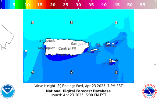
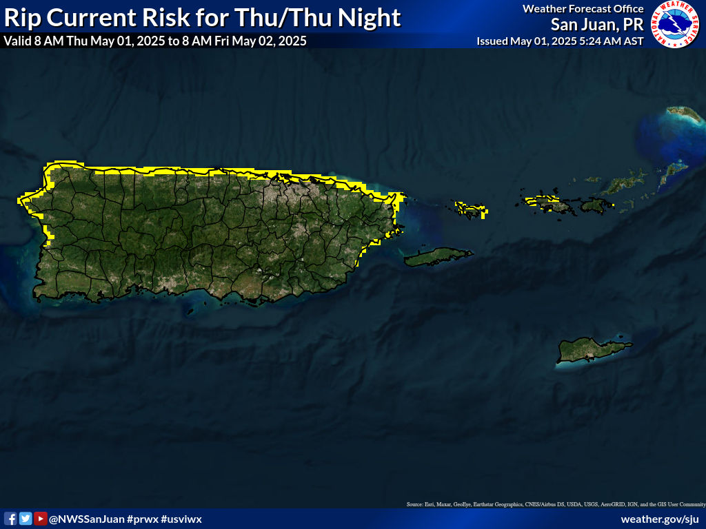
047
FXCA62 TJSJ 200107 CCA
AFDSJU

Area Forecast Discussion...CORRECTED
National Weather Service San Juan PR
907 PM AST Tue May 19 2026

...CORRECTED TO INCLUDE LONG-TERM DISCUSSION...

.KEY MESSAGES...
Issued at 104 PM AST Tue May 19 2026

* Hot and humid conditions will continue through the forecast
  period, with heat indices between 100 and 107F or higher
  possible across urban and coastal areas of Puerto Rico and the
  U.S. Virgin Islands. Vulnerable populations should limit
  prolonged sun exposure and stay hydrated.

* Breezy to windy east to east-southeast winds will continue through
  much of the week, bringing periods of passing showers across
  the U.S. Virgin Islands and eastern Puerto Rico, especially
  during the overnight and morning hours.

* Afternoon showers and isolated thunderstorms are expected each
  day across interior and western Puerto Rico due to daytime
  heating, local effects, and nearby troughing. Localized
  flooding, ponding of water on roads, and reduced visibility will
  remain possible.

* Weather conditions may become more unstable by early next week
  as an upper-level trough approaches the region, increasing the
  potential for isolated thunderstorms, gusty winds, and more
  frequent showers, especially across western Puerto Rico and the
  San Juan metropolitan area.

* Moderate rip current risk will continue along many north- and
  east-facing beaches of Puerto Rico and the U.S. Virgin Islands
  due to fresh to locally strong winds. Beachgoers should swim
  near lifeguards, and mariners should exercise caution.

&&

.Short Term(This evening through Thursday)...
Issued at 104 PM AST Tue May 19 2026

Under an east-southeast wind flow, the USVI and PR windward
portions observed periods of sunshine, with the arrival of clouds
resulting in brief passing showers; meanwhile, the leeward
portions of PR had mostly sunny conditions with warm to hot heat
indices. PR and the USVI`s maximum temperatures are in the upper
80s to the low or even mid-90s at coastal and urban sites, which,
combined with available moisture, resulted in heat indices between
100 and 107 degrees Fahrenheit or briefly even higher. The winds
were primarily from the east to east-southeast at 10 to 20 mph,
with stronger gusts up to 45 mph in windward locations, as
reported at Buck Island, St. Thomas.

The rest of this afternoon is expected to have warm to hot heat
indices in areas without rain. Thus, there is a limited risk of
excessive heating, which could impact the most vulnerable
communities. However, some showers will affect portions of the
USVI and PR`s windward areas, as well as the interior and
northwest quadrant of PR, due to sea breeze and excessive heating.
The risk of flooding is limited in the eastern half of PR and
elevated in the northwest quadrant. However, while driving, if a
shower moves by you, you may encounter limited visibility and
ponding of water where the shower passes.

At the surface, high pressure will build from the western to the
central Atlantic, tightening the local pressure gradient and
promoting breezy to windy east-to-east-southeast winds, although
variations due to sea and land breezes are expected each day.
Under this wind flow, the advective pattern will continue, with
occasional patches of moisture arriving, creating cloudy skies and
fast-moving showers, especially across the local waters and the
USVI and PR windward areas. Additionally, unlike last week, we do
not have a ridge dominating the area; instead, we have a nearby
trough that will allow the available moisture to dig deeper into
the mid parts of the atmosphere, allowing the potential to observe
locally induced stronger rain showers and one or two
thunderstorms, especially in the afternoon and evenings. Thus, we
will have a limited risk of flooding each day across portions of
PR. At the same time, for the USVI, we cannot rule out occasional
periods of moderate to locally heavy rain, which can reduce
visibility while in transit, or ponding of water in roads and
poorly drained areas.

The excessive heating will continue mainly due to the amount of
moisture combined with the maximum temperatures.

&&

.LONG TERM...(Friday through Tuesday)...
From early discussion issued at 320 AM AST Tue May 19 2026

A typical weather pattern is expected over the long-term
forecast, though conditions may become unstable by the end of the
period. A E- ESE wind flow should prevail as a surface high
pressure building over the Western Atlantic will linger for the
next several days, resulting in breezy conditions across the
islands. The latest model guidance suggest PWAT values remaining
typical for this time of the year (between 1.5 and 1.75 inches),
with patches of moisture arriving from time to time. Nevertheless,
moisture content is expected to increase early next week as the
upper-level trough extending into the tropics should migrate
eastward, approaching the local area. From the latest model
guidance solutions, the trough may become a cut-off low, and while
approaching the region, it should gradually cool mid-level
temperatures, with strengthening upper- level winds (250 mb winds
up to 60 kt). These conditions should allow cloud growth and
ventilation, favorable for deep convection. The most likely
scenario is for windward sections to expect isolated to scattered
showers overnight into the morning hours, with the highest
potential for isolated thunderstorms on Monday. The combination of
diurnal heating, local effects, and sea breeze convergence,
afternoon showers and thunderstorms are very likely each day,
particularly over the interior and half west of Puerto Rico.
Additionally, island streamers may move over eastern portions of
Puerto Rico, including the San Juan Metropolitan Area. Although no
significant flooding or lightning threat is expected, ponding of
water over roadways and poorly drained areas is very likely, along
with minor flooding. In addition to rainfall, hazards that can be
expected in this scenario include gusty winds and lightning.

Warmer temperatures for this time of the year are likely, with heat
indices exceeding 100 degrees Fahrenheit, particularly over urban
and coastal areas of Puerto Rico and the U.S. Virgin Islands.
Although the heat threat should remain limited, this level may
affect individuals sensitive to heat even more without adequate
hydration and long sun exposure.

&&

.AVIATION...
(18Z TAFS)
Issued at 104 PM AST Tue May 19 2026

Mainly VFR conditions across the terminals. The prevailing winds
will bring occasional rounds of -SHRA/SHRA near/around windward
terminals throughout the period. Thru 19/23Z, SHRA/+SHRA and isold
TSRA, will develop across the interior and NW, as well as
downwind from the islands and El Yunque. This will result in brief
MVFR conds over TJBQ, as well as near TJSJ/TIST/TISX. Expect each
day breezy to locally windy E to ESE winds at 15-20 kts with
higher gusts and sea breeze variations, decreasing after 23Z.

&&

.MARINE...
Issued at 104 PM AST Tue May 19 2026

A surface high pressure building from the western to the central
Atlantic will promote a fresh to locally strong east-to-east-
southeast wind flow, creating choppy to rough seas through at
least the middle of the week.

&&

.BEACH FORECAST...
Issued at 104 PM AST Tue May 19 2026

The breezy to locally windy conditions will continue throughout
the week across the region, maintaining a moderate risk of rip
currents along most local beaches, particularly along north and
east-facing coastlines. Therefore, beach visitors are urged to
swim only at beaches with lifeguards on duty, remain aware of surf
conditions, and avoid venturing too far from shore, as life-
threatening rip currents are possible across most of the region.

&&

.SJU WATCHES/WARNINGS/ADVISORIES...
PR...None.
VI...None.
AM...Small Craft Advisory until 6 PM AST Wednesday for AMZ711.

&&

$$

MORNING CREW...CAM/CVB
EVENING CREW...ICP/MNG
UPDATE...ICP