Hurricane Season runs from June 1-November 30


[10/10]


Area Forecast Discussion (AFD)
147
FXCA62 TJSJ 021829
AFDSJU
Area Forecast Discussion
National Weather Service San Juan PR
229 PM AST Thu Apr 2 2026
...New SHORT TERM, LONG TERM, AVIATION, MARINE, BEACH FORECAST...
.KEY MESSAGES...
Issued at 222 PM AST Thu Apr 2 2026
* Life-threatening rip currents will continue at north- and east-facing
beaches through early next week. While dangerous surf is
expected to gradually subside after this evening, conditions
will remain hazardous. It is advised to stay out of the water in
high- risk areas.
* Hazardous seas will persist through early next week, making conditions
unfavorable for small craft in local waters.
* Expect showers and isolated thunderstorms each afternoon,
becoming more widespread and stronger over the weekend. A
Limited to Elevated Flooding Risk will persist, along with the
threat of lightning and gusty winds.
* Breezy to locally windy conditions will continue, with stronger
gusts possible in exposed areas and near showers.
&&
.Short Term(This evening through Saturday)...
Issued at 222 PM AST Thu Apr 2 2026
Variable conditions persisted during the morning hours, with passing
showers moving across the regional waters into portions of northern
and eastern PR and the U.S. Virgin Islands. Based on the WSR-88D
rainfall estimates, some areas have received up to 1 inch during the
morning. Winds from the northeast strengthen, with CWOP/ASOS
stations reporting maximum wind gusts of up to 25 mph across the
islands, locally higher in areas such as the Luis Munoz Marin
International Airport, where a gust of 32 mph was reported. Taking a
look at the 12z RAOB, PWAT values (1.44 inches) remain near the mean
values (1.54 inches) for this time of the year, showing most of the
moisture content in the low levels (83 %). Additionally, cooler than
normal mid-level temperatures (500 mb temperatures around -8 degrees
Celsius) and strong winds aloft (250 mb winds around 90 knots)
should allow cloud growth and ventilation, leading to the
development of thunderstorms. Afternoon convection is currently
affecting interior, south and southwestern portions of Puerto Rico.
Accumulations should remain up to 2 inches, though isolated areas
may reach 3 inches. Due to previous rainfall activity across these
areas and above normal streamflows, the potential of flooding will
remain elevated. As of 2:05 PM AST, Flood Advisories are in effect
for Cabo Rojo, Hormigueros, Lajas, San German, Ponce, Penuelas until
4 PM AST.
A variable weather pattern will persist in the short term forecast.
Satellite-derived products show abundant moisture content reaching
the CWA, pooled from the deep-layered trough and induced surface
trough northeast of the Leeward Islands. A surface high pressure
over the north central Atlantic combined with the surface trough
will keep promoting a northeasterly wind flow, transitioning from
the east-southeast by Saturday. For tonight and early Friday,
passing showers will likely move across northern and eastern
portions of Puerto Rico and the U.S. Virgin Islands, though rainfall
accumulation will likely remain limited. Friday afternoon will
likely be similar to today, with showers and isolated thunderstorms
moving over interior into southwestern portions of Puerto Rico.
Ponding of water over roadways and poorly drained areas is
likely, including minor flooding.
As the deep layered trough migrates eastward, a mid to upper level
low will move near Cuba and the Bahamas by late Friday night,
bringing a jet streak over the CWA, with winds between 80 to 90
knots. The deterministic guidance of the GFS and ECMWF show abundant
moisture pooling into the region, reaching above normal values for
this time of the year. From the latest solutions, ensemble members
are tending to wetter conditions, with PWAT values between 1.8 and
2.0 inches. Nevertheless, the latest average simulated IR show cloud
coverage associated to the mid to upper level low that may move over
the CWA on Saturday, inhibiting afternoon convection. Additionally,
strengthening winds may promote more progressive showers instead
of stationary. Hence, the most likely scenario would be an
increment of showers moving over windward sections throughout the
day, while the afternoon convection will rely on cloud cover. At
the moment, the flooding potential will remain limited to elevated
for most portions of Puerto Rico, particularly over interior and
northwestern Puerto Rico and the San Juan Metropolitan Area.
Breezy to locally windy conditions will continue across coastal
areas of the islands, with winds between 15 to 25 mph and gusts up
to 30 - 35 mph.
&&
.Long Term(Sunday through next Wednesday)...
Issued at 225 AM AST Thu Apr 2 2026
A warmer and more humid pattern will support increasing afternoon
convection and a rising flood risk through midweek.
By Sunday onward, the surface pattern will be dominated by high
pressure migrating eastward into the Atlantic, promoting a shift
in low-level winds from easterly to southeasterly, which will
persist through most of the period. A mid- to upper-level
shortwave trough will induce a surface trough northwest of the
region, supporting continued advection and pooling of tropical
moisture into the area. Based on the latest guidance, precipitable
water values are forecast to slightly decrease on Sunday but
remain near to above normal for this time of year, around 1.6 to
1.7 inches. From Monday through Wednesday, as the induced
disturbance drifts northward, increasing low-level moisture from
the Caribbean will spread across the islands, with precipitable
water values rising to around 1.9 to 2.0 inches.
Given this pattern and the latest model guidance, the heaviest
rainfall is expected to remain north of the region over the
Atlantic waters. However, scattered passing showers will affect
the waters, the U.S. Virgin Islands, and windward sections of
Puerto Rico during the overnight and early morning hours, followed
by more widespread and better-organized afternoon convection
across interior and northwestern Puerto Rico. Local effects will
enhance shower and thunderstorm development each day. This
pattern, combined with warm and humid conditions, will increase
the risk of urban and small stream flooding, with flood risk
ranging from limited to elevated.
Temperatures are expected to trend warmer at the beginning of the
long-term period, with 925 mb values approaching the 75th
percentile, or about two standard deviations above normal. This
will further support instability and convective potential each
afternoon.
&&
.AVIATION...
(18Z TAFS)
Issued at 222 PM AST Thu Apr 2 2026
Mainly VFR conds expctd across most TAF sites, except JPS during
this aftn due to -TSRA, reducing CIGs/VIS and leading to MVFR
conds. VCSH will persist across northern and eastern TAF sites aft
02/23z. Winds will weaken and become light and VRB, strengthening
btwn 15 and 18 kt, with higher gusts aft 03/12z. VCTS cannot be
ruled out for JPS by 03/17z.
&&
.MARINE...
Issued at 222 PM AST Thu Apr 2 2026
Hazardous marine conditions are likely to persist during the weekend
and into next week. A strong surface high pressure system over the
Atlantic will promote fresh to locally strong northeasterly winds.
These winds will gradually veer to become more easterly late Friday
and east-southeasterly Saturday into Sunday. Pulses of northeasterly
swell and the above mentioned winds will maintain choppy to rough
seas across the regional waters, mainly over the Atlantic and local
passages. Frequent trade wind showers will continue to move over the
local waters, while isolated to scattered afternoon thunderstorms
may develop over the coastal waters, especially from the southwest
to northwest of Puerto Rico, drifting west-northwest with the
prevailing flow, with a slight increase in coverage over the
weekend.
&&
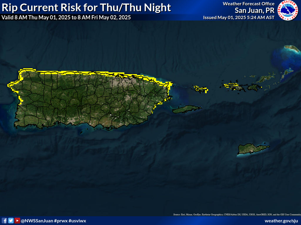
.BEACH FORECAST...
Issued at 222 PM AST Thu Apr 2 2026
A High Surf Advisory is in effect for the north-west northern and
eastern coastlines for Puerto Rico, Vieques, Culebra and the U.S.
Virgin Islands through this evening. Pulses of northeasterly swell
and fresh to strong winds will result in a High Risk of Rip
Currents along those areas through at least early next week.
Beachgoers and inexperienced surfers are strongly urged to stay
out of the water. Avoid walking along rocks or jetties, as large
breaking waves can sweep individuals into the sea without warning.
Always heed the advice of lifeguards and follow posted beach flags
and signs. Access to hazardous beaches may be limited, and
individuals should follow all posted warnings and safety guidance.
Visitors should also be mindful of the weather, in addition to
surf hazards. Like today, isolated thunderstorms and showers are
possible each afternoon, especially over W-SW Puerto Rico tomorrow
and W-NW Puerto Rico during the weekend. These storms may generate
dangerous lightning, so if thunder is heard, immediately seek
refuge inside a sturdy building.
&&
.SJU WATCHES/WARNINGS/ADVISORIES...
PR...High Rip Current Risk through Sunday afternoon for PRZ001-002-
005-008-010-012-013.
High Surf Advisory until 6 PM AST this evening for PRZ001-002-
005-008-010-012-013.
VI...High Rip Current Risk through Sunday afternoon for VIZ001-002.
High Surf Advisory until 6 PM AST this evening for VIZ001-002.
AM...Small Craft Advisory until 6 PM AST Sunday for AMZ711-712-716-
723-741.
Small Craft Advisory until 6 AM AST Friday for AMZ726-742.
&&
$$
SHORT TERM/AVIATION...MNG
LONG TERM...YZR
MARINE/BEACH FORECAST...MRR


![]()
Visits since November 23, 2005
Contact | Privacy Policy © 2025, WeatherPR.com – Your trusted source for Puerto Rico weather & travel tips.