Hurricane Season runs from June 1-November 30


[10/10]


Area Forecast Discussion (AFD)
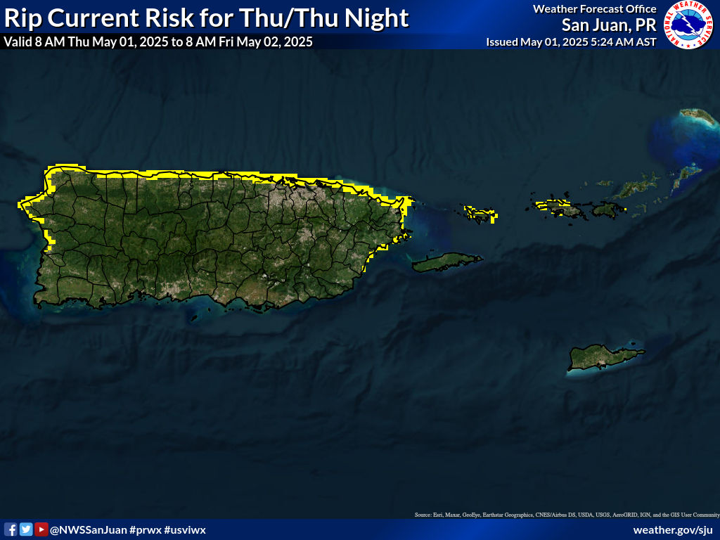
289
FXCA62 TJSJ 021905
AFDSJU

Area Forecast Discussion
National Weather Service San Juan PR
305 PM AST Fri Jan 2 2026

...New SHORT TERM, LONG TERM, AVIATION, MARINE, BEACH FORECAST...

.KEY MESSAGES...
Issued at 258 PM AST Fri Jan 2 2026

* Unsettled weather continues today, with afternoon and evening
  showers and isolated thunderstorms, increasing the risk of
  ponding on roads and localized urban and small-stream flooding,
  mainly across Puerto Rico`s mountain areas.

* For the US Virgin Islands, most showers will remain over
  surrounding waters, with brief passing showers possible at
  times, especially overnight and during the morning hours.

* Beachgoers, should exercise caution today into the weekend, as a
  Moderate Rip Current Risk continues, with life-threatening rip
  currents possible, especially along the exposed north and east-
  facing beaches in PR/USVI.

* By Three Kings Day, showers and isolated thunderstorms may
  become more organized. While widespread rainfall is not expected
  at this time, localized heavy rain and lightning remain
  possible. Continue to monitor forecast updates.

&&

.Short Term(This evening through Sunday)...
Issued at 258 PM AST Fri Jan 2 2026

As the mid- to upper-level trough axis swung over the US Virgin
Islands and Puerto Rico, cloudy skies and showers were observed
across portions of the islands, especially near St Croix, Vieques,
and the northern USVI during the morning. Cloud cover began to
slowly decrease over Vieques, St Croix, and portions of PR in the
afternoon, allowing temperatures to rise into the mid-80s along
the coast and into the upper 70s in the mountains. Winds were
mainly from east-southeast at around 10 mph.

A mid- to upper-level trough will continue to influence the
northeastern Caribbean tonight, with the axis exiting the region
by late tonight into tomorrow. Still, we have a chance to observe
periods of rain across portions of the islands under the
prevailing wind flow. The 12z TJSJ sounding detected a west-
southwest steering flow from the surface to the first 3km. Under
the steering flow, showers will move eastward across mainland PR,
and later this afternoon, we might see another round of rain
across the eastern half. However, model guidance has shown
significant inconsistency between their solution and the observed
weather. So, today`s and this weekend`s weather forecasts remain
challenging due to significant uncertainty in the model guidance.

Despite the current conditions, we anticipate calm weather for the
upcoming weekend. However, we cannot rule out some periods of
moderate to locally heavy rain in the interior regions of Puerto
Rico during the afternoon. Additionally, rain is expected in the
windward areas of Puerto Rico and the US Virgin Islands,
particularly in the early morning and evening hours. At this time,
we do not foresee any flooding risk, but we encourage residents
and visitors to remain alert to weather updates.

&&

.Long Term(Monday through next Thursday)...
Issued at 258 PM AST Fri Jan 2 2026

No major changes were introduced to the long-term forecast, with
a wet and unstable weather pattern early next week, gradually
improving by the mid week. As mentioned in the previous
discussion, the polar trough is still expected to deepen well
enough into the northeastern Caribbean, increasing moisture
content and introducing instability. Based on the latest model
guidance, PWAT values are likely to increase to above
climatological normal (up to 1.75 inches), with a high increase in
low to mid level moisture content. The presence of the trough
could bring cooler-than- normal 500 mb temperatures (between - 9
and -10 degrees Celsius) and strong upper-level winds (between 60
and 80 kt), which should enhance ventilation and allow cloud
growth, increasing thunderstorm potential. In addition to the
polar trough, another frontal boundary is expected to approach the
local area, creating a col region and weakening surface winds.
The most likely scenario for Monday into Tuesday is afternoon
convection, mainly concentrated over the mountain ranges of Puerto
Rico, with an advective cooling pattern during the night into the
morning affecting the northern portions of Puerto Rico and St.
Thomas and St. John in the U.S. Virgin Islands. With light and
variable surface winds, most of the showers and thunderstorms
should remain stationary, increasing flooding potential. Theres a
medium to high chance of rainfall accumulations leading to
flooding in urban areas, roads, and small streams. However, cloud
cover associated with the trough may be an inhibiting factor for
afternoon convection.

As the trough moves away, a surface high pressure exiting CONUS is
expected to build in the western Atlantic, increasing winds and
promoting a NE-ENE wind pattern. PWAT values should gradually drop
to below normal (between 0.9 - 1.1 inches) as a drier air mass
should filter into the region. Patches of moisture embedded in the
trades will arrive from time to time, bringing a few isolated
showers over windward sections, particularly at night into the
morning hours. Shallow afternoon convection is still likely each
day, particularly over western/southwestern Puerto Rico, although no
flood or lightning threat is expected during that period.

As winds are expected to become from the NE-ENE, temperatures will
gradually return to seasonal and even below climatological normal
based on the latest guidance. For urban and lower elevations,
minimum temperatures may remain in the low to mid 70s, with isolated
areas dropping into the high 60s. On the other hand, higher
elevations should remain in the 60s, with isolated areas dropping
into the mid to high 50s.

&&

.AVIATION...
(18Z TAFS)
Issued at 258 PM AST Fri Jan 2 2026

VFR conditions will prevail across all TAF sites during the
period. However, SHRA/isolated TSRA cannot be ruled out across the
interior and SW-PR later this afternoon. Most of the activity
should remain in the VCTY of local terminals and will dissipate by
the evening. Improving conditions overnight into tomorrow. Winds
will continue under sea breeze influence mainly from the ESE at
10-15 kt with higher gusts, becoming calm to light and VRB during
the overnight hours (23-13z) each day.

&&

.MARINE...
Issued at 258 PM AST Fri Jan 2 2026

As a surface high pressure builds across the Central Atlantic into
the northeast Caribbean, winds will continue light to moderate out
from the east to east-southeast through at least early next week.
Another frontal boundary and polar trough will approach the local
area by following Monday, promoting light northeast to northerly
winds and an increasing potential for showers and thunderstorms
early next week. A small northerly swell will arrive around late
Saturday into Sunday, and another pulse with longer period from
the northeast by the middle of next week.

&&

.BEACH FORECAST...
Issued at 258 PM AST Fri Jan 2 2026

Beachgoers, the main hazard remains the moderate risk of life-
threatening rip currents, especially along the surf zone of
exposed east and north-facing beaches in PR and the USVI. Please
exercise caution.

There is a limited to elevated chance of lightning across the
western and northern beaches of Puerto Rico, particularly this
evening and again on Friday afternoon. Remember that lightning can
strike several miles away from a thunderstorm. If you hear
thunder, seek shelter immediately.

&&

.SJU WATCHES/WARNINGS/ADVISORIES...
PR...None.
VI...None.
AM...None.
&&

$$

MORNING CREW...CAM/GRS
EVENING CREW....ICP/MMC


![]()
Visits since November 23, 2005
Contact | Privacy Policy © 2025, WeatherPR.com – Your trusted source for Puerto Rico weather & travel tips.